High Wall Mapping
Mapping open pit highways in mining operations is essential for safe and efficient transportation within the mine site. The following explores the methods employed by mining companies for highway mapping, the role of aerial data, specific data types generated, safety standards for highwall operations, and examples of highway disasters with insights into their prevention.
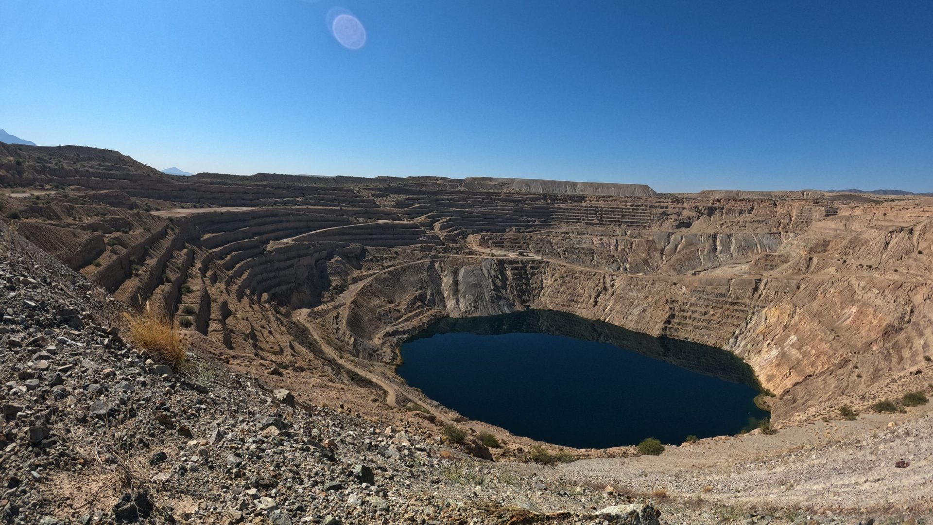
Open pit mining operations often span vast areas, necessitating the establishment of high-quality transportation networks within the mine site. These “highways” are crucial for moving personnel, equipment, and materials efficiently and safely. Effective mapping and monitoring of these highways are integral to the overall success and safety of mining operations.
Mapping Methods and the Role of Aerial Data
Aerial Data: Aerial data, collected through various methods such as drones, helicopters, or satellites, plays a pivotal role in mapping open pit highways. The following mapping methods benefit from aerial data:
GPS Surveys:
Global Positioning System (GPS) surveys are commonly used to collect accurate location data of highways and other infrastructure within the mining site.
Photogrammetry:
Aerial photography and photogrammetric techniques enable the creation of high-resolution orthomosaics and 3D models, which help visualize highway layouts and topographical features.
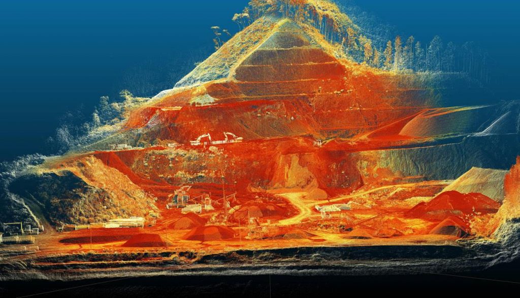
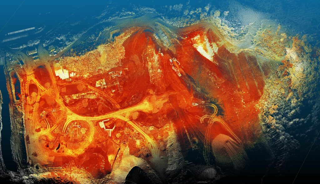
LiDAR Scanning:
LiDAR technology provides high-resolution, 3D point cloud data that can be used for detailed mapping, including the identification of highwall irregularities and potential hazards.
Multispectral and Thermal Imagery:
These data types offer valuable information for assessing vegetation health, monitoring road surface conditions, and identifying thermal anomalies indicative of underground fires.
Data Types and Their Utilization
Topographical Data:
Aerial data, including LiDAR and photogrammetry, generates topographical information used for highway design and optimization, aiding in the avoidance of steep or unstable areas.
Highway Condition Monitoring:
Regular aerial data collection and analysis enable mining companies to monitor the condition of highways, identify erosion, surface wear, and potholes, and plan maintenance.
Safety Assessment:
LiDAR and thermal imagery can be used to detect highwall instability, identifying areas at risk of rockfalls, slides, or structural failure.
Safety Standards for Highwall Operations
Safety in highwall operations is paramount, as accidents can result in fatalities and significant disruptions to mining activities. Key safety standards and practices include:
Highwall Stability Analysis:
Regular geotechnical assessments and monitoring of highwall stability are essential to ensure that highways are safe for use.
Blast Control:
Careful blasting practices are crucial to minimize highwall instability, ensuring the safety of highway users and surrounding infrastructure.
Warning Systems:
Warning systems, including alarms and sirens, can be installed to alert workers in case of highwall instability.
Examples of Mining Highway Disasters and Prevention
Omai Gold Mines, Guyana (1995):
A highwall failure resulted in the release of a tailings dam, causing significant environmental damage and risks to nearby communities.
Prevention: Comprehensive highwall stability assessments and monitoring systems could have detected instability early, allowing for corrective action.
Bingham Canyon Mine, USA (2013):
A massive highwall slide occurred, damaging equipment and infrastructure.
Prevention: Improved monitoring and early warning systems could have allowed for timely evacuation and reduced damage.
- Highway Geospatial Data: Accurate geospatial data is crucial for mapping open pit highways. This includes precise coordinates, elevations, and a detailed digital map of the highways, which can be used for route planning and design.
- Topographical Information: Topographic data, often generated through LiDAR and photogrammetry, provides detailed insights into the elevation, slope, and terrain characteristics of the highway network. This information is essential for designing safe and efficient roads.
- 3D Models: Three-dimensional models of the highways are invaluable for visualizing the layout, understanding potential hazards, and optimizing highway design. This aids in the identification of elevation changes, curves, and potential highwall instabilities.
- Highwall Stability Analysis: Data related to highwall stability, including the locations of potential instabilities and monitoring results, are critical outputs for safety assessments.
- Highway Condition Information: Regularly updated information on the condition of the highways, including surface quality, potholes, erosion, and maintenance needs, is essential for safe operations.
- Vegetation and Environmental Data: Multispectral and thermal imagery can provide information on vegetation health, land use changes, and potential environmental concerns along the highway network.
Safety Standards Calculation:
Safety standards for highway operations in mining are typically calculated based on a combination of factors, including industry best practices, regulatory requirements, and site-specific risk assessments. Here are some key considerations for determining safety standards:
- Regulatory Compliance: Mining operations are subject to regulations and safety standards set by local, national, and international authorities. Compliance with these regulations is a fundamental aspect of safety in mining operations.
- Geotechnical Assessments: Highwall stability and geotechnical assessments are conducted to evaluate the safety of highways in open pit mines. These assessments consider factors like rock quality, slope angles, and the potential for rockfalls or landslides.
- Blast Control: Mining operations often involve blasting activities. Safety standards related to blasting practices are essential to prevent highwall instabilities. These standards dictate factors such as blast design, timing, and monitoring.
- Warning Systems: Warning systems are established to notify workers and personnel about potential highwall instabilities or other safety hazards. These systems may include sirens, alarms, or visual signals.
- Emergency Response Plans: Detailed emergency response plans are developed to guide actions in the event of highway-related disasters. These plans define roles, responsibilities, communication protocols, and evacuation procedures.
- Monitoring and Surveillance: Continuous monitoring and surveillance of highwalls, highways, and nearby areas are crucial for identifying potential hazards. Data from instruments, including LiDAR scans and seismographs, contribute to safety standards.
- Risk Assessments: Risk assessments consider various scenarios and their likelihood to determine acceptable safety standards. These assessments help prioritize safety measures and allocate resources effectively.
- Training and Education: Ensuring that personnel are adequately trained and educated in safety procedures and best practices is an integral part of maintaining safety standards.
- Safety Culture: Fostering a strong safety culture within the organization is essential. This involves promoting a mindset where safety is a core value and responsibility of every employee.
Safety standards are dynamic and should evolve as new technologies and best practices emerge. Mining companies are encouraged to regularly review and update their safety standards to adapt to changing conditions and incorporate lessons learned from incidents and near-misses.
Mapping open pit highways in mining operations is essential for safe, efficient transportation within the mine site. Aerial data, including LiDAR, photogrammetry, and multispectral imagery, provides critical information for highway design, condition monitoring, and safety assessments. Adherence to safety standards and the use of monitoring technologies can help prevent highway disasters, ensuring the well-being of mining personnel and the longevity of mining operations. By leveraging technology and best practices, mining companies can enhance their highway operations and mitigate risks effectively.